Thursday 23 October 2008

Tuesday 12 Aug 2008: Lisburn, Scotland, and Home

OUR LAST DAY IN IRELAND. HEAVY RAIN was forecast overnight and during the day, and remembering the floods that had preceded our arrival by a day, the floods that just missed us as we drove around Dublin on our way to Belfast, and the torrents that we’d driven through on our visit to the Giant’s Causeway, we’d gone to bed apprehensive that the basement carpark might flood overnight.

But come the morning, all was well, and we managed to leave the apartment early enough to drive to Lisburn and visit the Linen Museum shop. We didn’t have time to see the museum itself, unfortunately, but we bought some Irish linen: “natural” placemats and serviettes, and a white embroidered and lace-trimmed traycloth for Margaret to use as dressing table runner.

We drove back to Belfast, and to the ferry terminal, where we had a long wait in obedience to the instruction, on our tickets, to be there 90 minutes before departure. There were a couple of columns of cars there already, but how virtuous we felt as, over the next hour or so, car after car drove up and was shepherded into column after additional column. Come loading time, we were last to drive aboard, which we thought would stand us in good stead for being first off at the other end.

Shoulda known better. The crossing itself was uneventful (we got some magneti of the ferry!), but when we got to Stranraer, ours was the last vehicle but two, and last car but one, to be let off the boat. We felt like emailing the ferry company and telling them where to stick their “ninety minutes before sailing”!

Still, no harm was done, and the drive through the Scottish countryside from Stranraer down to Carlisle, and through England from there to Acton and home, was as uneventful as the crossing—for us, at least. Our route from Stranraer took us eastwards along the A75, skirting to the south of Newton Stewart, and from there along the scenic A712 tourist route called “The Queen’s Way” (in commemoration of her Silver Jubilee in 1977). It was about 20 minutes out of Newton Stewart that we heard on the traffic reports that the road there was now closed in both directions due to a very nasty accident at the intersection of the A75 and the north-south A714.

We got home about 9:30 p.m., tired after 2,300 miles of travel, but happy, and with some pretty linen, a small clutch of bookmarks, a larger clutch of fridge magnets, a pretty vase, some whistles, several books, a mountain of photos, and an ocean of memories.

It was three days later that the floods hit Belfast … “Some places in central and eastern Northern Ireland saw up to three-quarters of the August rainfall in a single day,” and the newly-built Broadway Underpass was under 5m of water. We were sorry for the Irish people who were affected, and so glad to be back at home.

Sunday 19 October 2008

Monday 11 Aug 2008: Newgrange

WHEN WE DROVE FROM THE IRISH Republic back into the United Kingdom, there was no fanfare, and in fact the transition from one country to another seemed to be completely unmarked (possibly because it was straddled by road works), apart from the change from kph to mph—which may have caused a problem till Don suddenly realised he was driving at 30 mph, thinking that the 50 sign still meant kph.

It was much the same when we drove back down into The Republic today, and probably for the same reason—But pause! Rewind! We drove back down into The Republic today? What was that about?

It was about the fact that we’d intended to visit Newgrange on the way out of The Republic, but had been waylaid by Tara instead (having stumbled across it first). No regrets about Tara—everyone should visit!—but Newgrange remained very high on our lists of “must sees”, so—why not?

We made breakfast in our kitchen, from the supplies we’d bought at Tescos, then went down to the basement and took the car up onto the Lisburn Rd and down to the M1. About 100 minutes later (around 11 a.m.), we pulled up in the Newgrange car park.

People (including kiwis back home) say to us, “You’re from New Zealand? That’s such a beautiful country! What the heck are you over in the UK for?” Well, of course, the Republic isn’t part of the UK, but the same answer does for both: the British Isles are beautiful too, and they have something NZ lacks: ancient (pre)history!

(But they’re not really “home” …)

Ancient (pre)history! You might think from our travels so far we’d had enough of it, but not us! Newgrange is one of the places that ancient (pre)history buffs just have to visit if they get the opportunity just once in their lives! (Not to mention sprinkling exclamation marks around like crazy! But when you ain’t got much to say, say it with vigour, yassuh!)

And ancient (pre)prehistory buffs don’t come much more ancient (or buffy) than us … …

Ahem. After a bit of a quiet lie-down, Our Author continues …

You can’t get to the site except via the Visitor Centre, and when we got there we found you have to be organised into tours. Newgrange is part of a wide sacred landscape (the Brú na Bóinne complex), and initially we booked into a tour that would also take us out to Knowth (an associated site, about a mile away, apparently as spectacular as Newgrange, but in different ways). But a wee bit of questioning showed that if we took just the Newgrange tour, we might be able to satisfy one of Margaret’s ambitions, too, visiting the Lisburn Linen Museum on the way back (since the Nottingham Lace Museum which we’d hoped to visit on an earlier occasion had closed down); so we booked onto the 1:45 tour of Newgrange only.

If you have to visit a Visitor Centre, we’d thoroughly recommend the one at Newgrange. The initial exhibits are a series of brilliant models showing the landscape around Newgrange, both as it is, and at various periods during its development from around 3,300 BC, until it disappeared from view as a human structure around 2,000 BC; then you come to dioramas and reconstructions of Neolithic living.

So what is Newgrange? It’s a prehistoric chambered mound representing a tomb and religious centre with astronomical implications. It’s BIG (a rough circle 250 feet across and 40 feet high), and it’s OLD—older than the oldest Egyptian pyramid, and older than the stone circles at Stonehenge. And it’s ASTRONOMICAL: once a year, at the time of the winter solstice, the sun shines directly along the long interior passage into the central chamber for about 17 minutes as it rises, and illuminates the chamber floor for a very short time.

It’s also visually spectacular, but we’ll come to that shortly. We toured the Visitor Centre, bought the inevitable couple of guidebooks, and lunched in the café, and then it was time for our group to make their way to the bus stop. This took us across a footbridge over the flooded River Boyne, reminding us of the floods we’d missed just two days before. “Brú na Bóinne” means, “The Palace of the Boyne”; the river is supposedly named after the local river goddess Boaná, “She of the White Cow”; she was the mother of Young Angus, Aengus Óg, god of love and lovers, of poetry, and of the dawn. Newgrange was the home of the gods, the Tuatha dé Danaan (“Too-aha jay Duhnairn”, very roughly), and of Aengus Óg’s father, “the Dagda”.

Our first, exciting, view of Newgrange was from the bus. Seen over the top of the hedge that borders the lane, its white quartz façade gleamed against the lowering clouds. The façade is controversial: after the mound had gone out of use, its sides collapsed outwards until it looked like just another hill; its nature was only rediscovered during Michael O’Kelly’s excavations starting in 1962. As well as excavating, O’Kelly did much restoration, as part of which, the white quartzite and dark granite stones that were 
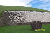
found buried in the slippage at the front of the mound were placed into a near vertical steel reinforced concrete wall. Critics say that the technology to achieve anything like this didn’t exist until modern times; a similar mound at Knowth has been reconstructed with the stones laid out to form a sort of “apron” before the entrance. But the sight of the arrangement at Newgrange, the white quartzite at the front shading round through the grey granite at the sides, is surely spectacular!

You can also see, on the last photo and on this, some of the “kerbstones” that line the perimeter of the mound. There are almost a hundred of them, most recumbent but some upright; many are decorated with megalithic art (incised rings, spirals, wavy lines, and lozenges), though Knowth is apparently much more magnificent in that respect. But the entrance to the passage that runs into the mound is guarded by a wonderful stone, reckoned as “one of the most famous stones in the entire repertory of megalithic art”, which may represent the sacred landscape itself, with the waves of the river at the base. (Well, that’s one of several interpretations.)

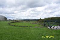
There are several ruinous prehistoric monuments around the mound (which is the only one that’s been restored), and there was time to wander round them while keeping one ear open for the guide’s explanation of the site. But the climax of the visit always 
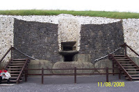
takes place inside the mound. You have to climb up and down some steps that lead over the fronting stones, then duck your head (unless you’re vertically challenged) to enter the doorway. Inside, the 19-metre (20-yard) stone-lined passage follows a slightly wavy path up a slight incline, to the central chamber, the floor of which lies a fraction above the level of the top of the entrance doorway to the mound.

The central chamber has a magnificent corbelled (overlapped stone) roof, six metres high (20ft), which, the guide assured us, “has never leaked in 5,000 years.” (This is almost certainly true!) There are three semi-circular recesses off the central chamber, making a sort of cross shape, quite common in these prehistoric mounds both in Britain and Ireland, and in Europe. The guide talked us through all this, but the magical part came at the end, when she switched out the lights. We all stood in an expectant, and slightly awed, silence, until, after a few seconds, a golden glow crept up the floor of the passage, and fell on the chamber floor at our feet. It lasted for a breathless a quarter of an hour, before fading gradually away.

This was a simulation of the phenomenon that occurs each year at sunrise on December 21st, the Winter Solstice. After an interval of a couple of thousand years, Michael O’Kelly was the first person in modern times (1967) to see it. There are other megalithic sites that show a similar phenomenon, but only here does the light enter through a specially-constructed “light box” above the entranceway, and only here does it exactly graze the walls of the sinuous passage leading to the chamber. Photography within the mound is, of course, forbidden …

There’s never time enough, particularly with a site so rich as Newgrange, and all too soon we had to get back on the bus and return to the Visitor Centre. We took a last look round the shop (an excellent magneto of the front kerbstone, but no bookmarks or cross-stitch), walked back to the car, and headed north in hopes of getting to the Lisburn Linen Museum.

It was pretty hopeless, really, thanks to heavy traffic and constant road works: we got to Lisburn just as the museum and its shop were closing (5 p.m.); quite a disappointment, on our last day in Ireland (going home tomorrow). But as a consolation prize, we went back to the apartments via the Lagan Valley Regional Park, “a mosaic of countryside, urban parks, heritage sites, nature reserves and riverside trails”, though we had time for only one of its features: the 
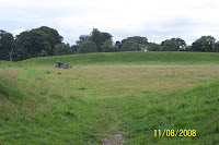
Giant’s Ring, one of the finest raths or henges (circular earthwork enclosures) in the British Isles, dating from around 4,700 years ago. More than 200 metres across, with a bank now reduced to “only” four metres high (that’s 13 ft), it lies about five miles from Lisburn and four from central Belfast.

In the centre is a dolmen, the remains of an ancient earth-covered tomb, with the earth long-since gone. If you can do the “cross-your-eyes” trick, the two photos here, showing the dolmen and the bank beyond it, make a stereoscopic double.


During the 18th century, the Giant’s Ring was used for horse-races and ploughing competitions, but it was rescued in 1847 by the local land owner, who put up a wall round it. A stone let into the wall reads:
THIS WALL FOR THE PROTECTION OF
THE GIANT'S RING
WAS ERECTED A.D. MDCCCXLI BY
ARTHUR VISCOUNT DUNGANNON
[On whose] estate this singular relique of
[the ancients] is situated and who earnestly
recommends it to the care of his successors.
Thankyou, Lord Dungannon …

Sunday 12 October 2008

Sunday 10 Aug 2008: Giant’s Causeway and Bushmills

YOU CAN GO LOTS OF DIRECTIONS FROM Belfast; we decided to go north.

Well, okay, a little west of North. Destination: the Giant’s Causeway. Getting there would have been easy, if we’d had an Internet connection and could dial up Google maps (or whatever); but all we had was the AA Road Atlas of Ireland, which was fine for general directions (M3, M2, A26 …), but deficient when it came to a map of Belfast: there was one, but we weren’t on it.

So, we took totally the wrong direction (with the benefit of hindsight!), roughly 180º wrong, in fact; but we wombled around as usual, and eventually found the right route.

Once we’d got under way, the drive took about two hours. In southern Ireland, we’d seen several houses flying flags with the local county colours: the yellow and green of Kerry; the red and white of Cork; the blue and white of Waterford … In Ulster, our route took us through some extremely neat villages festooned with Union Jacks and St George flags, like bunting for a royal visit. Regrettably (in hindsight), we didn’t stop for a photo.

We also didn’t stop to photograph any of the bands of very heavy rain that were sweeping across from west to east. We must have passed through four or five of them, each one requiring us to slow down, turn on the headlamps, and put the windscreen wipers on full. We thought of the floods there’d been down south (and not very far down south, really) the day before …

We got to the Giant’s Causeway about 1 p.m., during a dry (non-raining) and even partially sunny spell. Despite the weather, there was a long queue for parking, during which we took some very atmospheric photos of the weather sweeping across the mouth of Lough Foyle. Fortunately, we managed to dodge it when it fell.

You have to pay to visit the Causeway itself, which we duly did, and that entitled us to use the courtesy bus (which was yellow). It’s quite a long way down to the beach, and along the way we had official guide Colin to regale us with myths and legends—and some real geology—about the Causeway and its origins. The ride down alone was pretty scenic, taking us past (amongst other attractions) Finn MacCool’s stone camel and his petrified granny (who overdid it one day at the Bushmill’s distillery. Colin later admitted to us that he’d made that bit up).

We learnt from Colin that the Causeway, and related formations in Ireland and Scotland, was made (or its foundations laid) 60 million years ago, when volcanic eruptions filled river valleys with lava which cooled and solidified. Where it cooled slowly and evenly, it formed the hexagonal pillars that everyone knows about at the Causeway; where it cooled rapidly, it left chaotic jumbled masses. You can see where pillars meet chaos in the cliffs to the east of the Causeway.

The locals know that this is just a modern myth, of course; the truth of the matter is that the Giant of the Giant’s Causeway was none other than the aforementioned Finn MacCool, whom we previously met on the Dingle Peninsula. Though he fought many battles in many parts of Ireland, hereabouts was his actual home, and the story is well known of how he built the causeway so that a rival Scottish giant, Benandonner, could cross the sea to be whomped.

But as big Ben approached, Finn realised to his horror that his opponent was a larger and more fearsome rival than he anticipated. He fled to his home in the nearby hills, and like any sensible man, asked his wife for advice. Oonagh, a practical woman, disguised Finn as a baby, complete with large nightgown and bonnet. She placed him in a huge, hastily made cradle, telling him to keep quiet and pretend to sleep, as Benandonner’s great shadow darkened the door. Oonagh brought the Scottish giant in for tea, pleading with him not to waken Finn’s child, Looking at the massive ‘baby’ lying in the cradle, Benandonner took fright, saying that if this was the child, he had no wish to meet the father. He fled back to Scotland, ripping up the Causeway behind him, terrified that the awful Finn might follow him home.

(According to Colin, who actually seemed to know what he was talking about re the geology, the “matching” formations in the Hebrides, including Fingal’s Cave—“Fingal”, a.k.a. Finagle, being Finn MacCool—are from a different lava flow of about the same period, and not directly linked to the Giant’s Causeway.)

We clambered (and sat) on the Causeway, fascinated not just by the scale of the thing, but by its fine detail. There are, of course, “features” to look out for, such as The Wishing Chair (made for Finn when he was a child, it will grant your wish if you sit in it), but Don was intrigued by “Finn’s patio paving” and “Finn’s patio pool”, never previously described …

The weather was still sunny, despite a couple of spits of rain, and we spent some time on the main Causeway (there are three parts; the photo shows the Wishing Chair on Middle Causeway) before catching the bus back up to the Visitors’ Centre at the top of the cliffs. There we shopped for magneti (found a good one of the Causeway), a bookmark (ditto), the inevitable guide books, and—at last—the very T-shirt we’d wanted for Don in Killarney, but been unable to get in the right size. No cross-stitch, but Margaret found one later on the Internet. And we sat and leafed through the booklets while we had another very late lunch.

Colin’s reference to Finn’s Granny’s love of Bushmills whiskey was an apt local reference. Ireland once had many thriving whiskey distilleries, but thanks to astute marketing and large-scale production, inferior Scottish whisky flooded the worldwide market, and Irish whiskey had to struggle to catch up. The spelling with an “e” was adopted in the 1870s to mark the distinction, but economic difficulties caused the closure and merger of many distilleries, so that Ireland now has only three to the ninety or so in Scotland (which all have improved immensely since the 19th Century). And one of them is at Bushmills, five miles to the south of the Causeway.

Don has a taste for peaty malt whiskies, which we indulged while in Scotland, coming back with both peaty Islay whiskies, and smoother Highland and Speyside whiskies, so we could both educate our palates. But neither of us had ever tried Irish whiskey (incredible as it might seem), so now was our chance.

We got to Bushmills (the name of the town, as well as the distillery—it’s on the River Bush, probably an old Celtic name) about four in the afternoon, just in time to miss the last distillery tour; but we’d toured the Aberfeldy distillery in Scotland, and weren’t too disappointed. Instead, we made our way to the shop and the Distillery Kitchen Restaurant in the hope of a tasting. There we had a treat: a tasting tray, with four whiskeys (two blends and two malts), arranged on a leaflet which explained what they were and what you should expect to smell and taste. We both enjoyed the flavours (and Margaret enjoyed her cheesecake); in the shop afterwards, we bought a Bushmills fridge magnet, half-bottle samples of several whiskies, and a Glencairn tasting glass to complement the one we’d bought at Glenfiddich in 2007.

On our way back to Belfast, we went out of our way a little to drive through Coleraine, “the capital of the Causeway Coast”, in honour of the wonderful and celebrated Coleraine wine from Te Mata in New Zealand’s North Island, of which we have several bottles from several vintages maturing as they await our return to Wellington.

But back in the Lisburn Road, we bought Irish KFC and blobbed in front of the TV again, while the rain pelted down outside. So ended an almost Gaelic-free day.

Wednesday 8 October 2008

Saturday 9 Aug 2008: To Belfast, via Tara

As I was goin' over the far-famed Kerry mountains,
I met with Cap’n Farrell and his money he was countin’.
I first produced my pistol then rattled forth my rapier,
Cryin’, "Stand and deliver, for there’s no-one here to save ya!”

Mush-a durum durrum da,
Whack fol the daddy-o. Whack fol the daddy-o,
There's
whiskey in the jar!

WE FAREWELLED AGHADOE Cottage and Killarney, and drove off up the N71 and N21 to Limerick, then along the N7 to the M7 and Kildare, and onto the M50 that rings Dublin on the west side. From there, the N3 took us northwestward to Jordanstown, where we turned southwest, and so (after four hours or so driving) came to …

The Hill of Tara

… (Teamhair in Irish, either “High Place” or, as scholars now believe, “Hill of the Dark Earth-Goddess”), was once a place of burial and ritual assembly, the supreme religious centre in pagan Ireland. It’s said that one hundred and forty-two High Kings reigned from there in prehistoric and historic times. There are more than thirty known earthen structures in the ritual landscape atop the Hill, forming an unbroken sequence spanning some 4,000 years from around 3500 BC up to the 6th or 7th Centuries AD.

You get there from the carpark by walking the footpath to the Information Centre, formerly St Patrick’s church, under the stern eye of De Oul’ Shintleman himself (real name: Maewyn Succat. St Patrick was Welsh). His biographers claim that it was here he had his most famous victory over the pagan druids, during the reign of the 5th Century king Laoghaire, whose father Niall had sold him into slavery.

The hill was busy with tourists and sheep, and (in a different sense) with a remarkable set of mounds, hollows, ditches, and walls. At least as remarkable was the view, despite the cloudy and rather moist weather; on a fine day, half the counties of Ireland are supposedly visible from the top, which must be one of the reasons for its ancient sanctity.

We crested the so-called Mound of the Hostages (Dumha na nGiall) in the King’s Fort, and gazed into the entrance of its passage tomb, where we could see the spiral forms of Neolithic art (perhaps 3,000 BC) carved into the orthostats (upright slabs). It is said—but a lot of things are said about Tara—that they represent the journey of the soul into and beyond death. The mound was used for burials over a period of 1500 or so years; excavation found the remains of many bodies (between 250 and 500) in layers beneath the passage, but the mound was very carefully restored when the excavations were completed.

We viewed the ring-mounded King Cormac’s House (Teach Cormaic) from inside and out, and saw the Stone of Destiny, the Lia Fáil, on top of the nearby mound called the Forradh, the Mound of Inauguration. Here (perhaps) the High Kings of Ireland were proclaimed and crowned, while the Stone roared with joy at their feet upon it, or at the touch of their chariot axles. It is from this stone that the divine race, the Tuatha de Danaan, named Ireland “Inis Fáil”. (But the Scots say it was taken from Ireland to Argyll by Kenneth MacAlpin, and became the Stone of Scone. Even at Tara, its original site and even its original shape are unknown. The stone that stands at Tara, five feet above the ground and seven feet below it, is the most phallic ancient stone in Ireland ...)

The weather had been chancy all day, and while Don was walking round the Teach Miodhchuarta, the so-called “Banqueting Hall” (a long, narow, banked enclosure which was probably a ceremonial avenue), there was a peal of thunder. We made it back to the car in time, but our drive northward to Belfast was punctuated by bursts of heavy rain.

We had intended to go to another neolithic site, ranking almost as high as Tara, Newgrange; but we heard from a guide at Tara that Newgrange closed at 5, and since it would be almost that by the time we got there, we saved it for another day.

We’d booked ahead for Belfast, an apartment in Cordia Serviced Apartments. According to its postcode, it was quite central to Belfast, which suited our intention to see a little of the city as well as of the province. But when we’d navigated our way there (aided by Google Maps), it was so obviously not the right location for the apartments! We phoned the number on the reservation confirmation, and found the actual address was further out of town than we’d wanted. We found the place (on Lisburn Rd), but the first apartment we were sent to lacked several of the features we’d been promised, in particular an en suite and a view of the Black Mountains (it was on the wrong side of the building!); so we complained and got moved to a much nicer two-bedroom apartment on the top floor and on the opposite side; so we got our Black Mountains view after all, and a balcony to view it from!

Having settled in, but having little by way of food and drink, we made it to the next-door Tescos (dashing through the rain) just in time to buy dinner and supplies before they closed. Then we blobbed in front of the TV (watching I Robot); and saw about the record-breaking flooding on the roads around Dublin, not more than half an hour after we’d passed through. Shades of our arrival a week earlier!

Sunday 28 September 2008

Friday 8 Aug 2008: Around Killarney

WE'VE ALREADY WRITTEN A little about Killarney. It’s not seen as a tourist town without justification: there’s lots to see and do in the immediate vicinity of the town, and today we decided to do some of it.
So we took the N72 westward to Fossa, and thence south to the Gap of Dunloe (Bearna an Choimín), which lies across the far side of Lough Leane from Killarney. The Gap provides “a single-lane dirt track up a 6-kilometer ravine carved by glaciers;” it slices a deep V southward through Ireland’s highest mountains, with Tomi’s Mountain (Ná Tóimi) and the heather-covered Purple Mountain (An Sliabh Corcra) on its eastern side, and McGillucuddy’s Reeks (Cruacha Dubha) to the west.

The Gap’s craggy scenic grandeur is internationally famous, and it’s very popular with tourists, as you’d expect of a feature billed as “One of the most beautiful glaciated valleys in western Europe”. The route there takes an “unmarked road to the left” from the N72 (thus Guide Killarney, but when we got to it, the turning was clearly signposted: “Gap of Dunloe”), and down past Dunloe Castle, from which the Gap gets its English name.

The upward-sloping southward road leads towards the mouth of the funnel formed by the mountains to either side, and it’s there, at the bottom of the pass, that you’ll find the car park and Kate Kearney’s Cottage, now (and for a long time since) a café and pub. No-one knows who Kate Kearney was, or even if she really existed, but her reputation is as a moonshiner and a bit of a goer:

Oh have you not heard of Kate Kearney,
Who lives on the banks of Killarney,
At the glance of her eye,
Shun danger and fly,
For fatal's the look of Kate Kearney.

Tho' she looks so bewitchingly simple,
There's mischief in every dimple;
And who dares inhale
Her mouth's spicy gale,
Must die by the breath of Kate Kearney.

The car park turned out to be important. Although cars aren’t banned in the Gap, they’re strongly discouraged “between 10 a.m. and 5 p.m.” (as the sign said) because, as already remarked, it’s “a single-lane dirt track” which (more to the point) is chocker in the season with the slow-moving traffic of pony-drawn jaunting carts.

So we parked the car, and negotiated with the jarvies. This proved a little tricky as (not anticipating being unable to use the car) we’d got plenty of money on us, we’d thought, but it was still less than they wanted. But one took pity on us and arranged for a young colleague, “Michael O’Sullivan” (we later learned), to take us up “to the fifth lake” at a discount.

The fifth lake is the topmost one, beyond which you come to the precipice called “the Madman’s Seat,” at the Head of the Gap, and begin the descent into “the Black Valley” on the far side. (It costs extra to complete the last stretch to the top, and a lot more to go down the other side.) The lakes are connected by the Loe River, after which Dunloe Castle is named.

The jaunting cars are widely described as “a rip-off”, and Margaret’s colleague Tom had warned us against them along those lines. Perhaps such critics mean the cars in Killarney itself, for we both felt that Michael and his pony, Mingey (if we caught the name correctly, but it was probably something in Irish; the photo is a different car and pony) worked hard to give us value for money, over more than an hour’s round trip.

We sat side-by-side in the car, with Michael in front driving Mingey. At first we ascended a leafy lane, with trees either side to conceal the scenery (though of course, the trees were scenery!). Soon the view opened out to show the steep glaciated sides of the mountains, with heaps of till at the feet of the cliffs. It wasn’t cold, though cloudy and breezy, but it was a rather bleak scene, with bare rock, grass, ferns, and heather; the trees had been left behind.

The first lake is called Coosaun Lough (“Lough” being, by the way, an English spelling; in Irish, it’s spelt “Loch,” just as in Scottish!). The breeze rustled in the grasses, sent the dandelion heads nodding, and ruffled the waters of the lake, by the side of which there were several fishermen. At the head of the lake, the road climbed up to the next little valley, crossing the river by a low- walled bridge, and thereby crossing from the western to the eastern side of the Gap. Looking back, we could see another jaunting car coming up behind us, and a panorama over the Killarney hills in the distance beyond.

Above Coosaun is a larger lake, known as the Black Lake because (it’s alleged) of the shadows cast by the mountains. Ironically, The Irish name for the Black Lake is Loch an Chuasáin, “Lough Coosaun”, which the strangers (as the Irish call the English when they’re being polite) have apparently applied to the wrong lake! (It's Ventry all over again!) Here we saw a heron; although there are supposed to be eagles in the mountains, this was the only bird we saw (or heard, not that it made any sound) throughout our ride up the Gap and back.

At the head of the valley is a cottage which we didn’t photograph because we didn’t know its significance. Reputedly, it’s the cottage of “the Colleen Bawn” (the “Fair Lass”), a fifteen-year old girl “of outstanding beauty” (real name Ellen Hanley) who was murdered in 1819. In reality, the tragedy unfolded in Counties Limerick and Clare, but when it was fictionalised as The Collegians by Gerald Griffin, a reporter of the original trial, the author transferred the central action to the romantic landscape around Killarney (whence the title of Sir Julius Benedict’s later opera, The Lily of Killarney).

Griffin renamed the girl “Eily O’Connor” and had her secretly marry one “Hardress Cregan”, who prepared a hideaway for her until the secret could be made known: “You have heard me speak of Danny Mann's sister, who lives on the side of the Purple Mountain, in the Gap of Dunlough? I have had two neat rooms fitted up for you in her cottage, and you can have books to read, and a little garden to amuse you, and a Kerry pony to ride over the mountains.”

Ultimately, Danny Mann (Cregan’s manservant) murders Eily by throwing her off a boulder into a river, and enterprising locals have identified the very rock near the northern shore of Mucross Lake; a little south of Killarney—reputedly a very nice place to swim! “A stones throw from the beach lies a small but most striking rocky island, perhaps the most famous piece of limestone in Killarney, the Colleen Bawn Rock.”

The road became very narrow above the Black Lake, and it became very clear why cars are frowned upon. Not that everyone bothers to read, or regard, the notice down at Kate Kearney’s. Michael told us that there’d been a serious accident on the road about a year previously, involving a tourist’s car and a pony and trap.

The upward road passes Cushnavally Lake on the right, before leading up to the largest lake, Auger. There are ruins at the north end of the lake which, if we have it correct, are the remains of an old police barracks.

At the other (upper, south) end of Auger Lake, the road rises very steeply between tall, boulder-strewn cliffs, and here Michael had to get down to relieve the weight, and lead Mingey into a trot to provide momentum for the upward trail. The valley walls closed in on either side, with the road clinging to the western flanks of the Purple Mountain, the river below concealed amongst the jumble of huge squarish boulders that had fallen from the sandstone hillsides. Tennyson visited the Gap in his youth, and the famous echo hereabouts (we later read) is said to have inspired his poem, The splendour falls:

The splendour falls on castle walls
And snowy summits old in story:
The long light shakes across the lakes,
And the wild cataract leaps in glory.
Blow, bugle, blow, set the wild echoes flying,
Blow, bugle; answer, echoes, dying, dying, dying.

The roadway led back across the Loe by a stone bridge, and looking back, we had a wonderful view northwards down the valley towards Beaufort and the fertile lands to the west of Killarney. (And the walkers following up behind us.)

We came at last to the uppermost lake, Black Lough, whence St Patrick is supposed to have banished the very last snake in Ireland. Here we were allowed a glimpse of the next bridge over the Loe, but we hadn’t paid to be taken that last, difficult, kilometre to the Head of the Gap, so Michael turned Mingey and the car around, and we began the journey back down.

Our jaunting-car ride had certainly been worth what we had paid; and it had made a change, being driven instead of driving, and so being able to watch more (and photograph more) than might otherwise have been the case. However, it had consumed virtually all the money we had on us, so we drove back up to the N72 and back into Killarney to find an ATM.

Moneyed up again, we drove south through the town and past the “Lower Lake” and Muckross or “Middle Lake” with the purpose of seeing for ourselves the celebrated Bricín Bridge (see Tuesday 5 Aug 2008: Killarney) which crosses the “Meeting of the Waters” where the water from the “Upper Lake” (Loch Uachtarach, “Lake Superior”) is channelled down through the rocks into Loch Mhucross. This is one of the great beauty spots of Ireland, but we were destined not to see it, since it can only be reached on foot or by jaunty car, and we’d had our jaunt for the day!

Instead, we reversed out course and drove back through Muckross village (Mucros, “Pig Wood”) almost to Killarney. Turning left at Scrahane, we drove through cultivated woodland onto the Ross Peninsula and so to the car parks of Ross Castle.

The peninsula juts out into Lough Leane (Loch Léin), the “Lower Lake”, about a third of the way up its eastern shore. The castle was built in the 15th Century for the O’Donoghue chieftains, on a site overlooking Ross Bay, formed by the northern shore of the peninsula. The interior can only be visited as part of a tour party, and we were unwilling to join one since they always go so much faster than we want to, being incurable seekers after fine detail. We contented ourselves with viewing the castle’s exterior, and the lovely views out over the bay—and watching the happy bridal parties who are drawn like summer mosquitoes for their photo-shoots. (There were three there already, and another was arriving as we left!)

Ross Castle was one of the last stongholds in Ireland to surrender to Cromwell’s forces, in 1652, and there is a romantic legend of Amy Browne, The Maid of Ross, daughter of the castle warden at the time. The beginning of the story is told at AnswerBank, but the full account doesn’t seem to be on the Internet, so we are providing it for ourselves right here: The Maid of Ross: A Killarney Legend! (Googling “Maid of Ross” returns several hits for an Australian race horse of that name.)

Had we been able to continue through the Head of The Gap of Dunloe, we would have been taken down to the west end of Loch Uachtarach, the Upper Lake, and boated its length to Newfoundland Bay, where the N71 from Kenmare via Moll’s Gap almost touches its eastern shore (see Monday 4 Aug 2008: Ring of Kerry, and our First Seisiún). Not having done that, we decided to do the best we could, and reverse that course, to some extent at least. We drove back down the N71, past the turnoff for the Bricín Bridge, and pulled in at a parking area overlooking Newfoundland Bay. There was a camper-van already there, and we had a pleasant exchange with an elderly couple of vintage hippies … The rocks at the lake’s edge had been worn by the water into fascinating and beautiful rounded shapes …

We continued down the N71 and up to Lady’s View, where we took still more photos of the panorama out over Loch Uachtarach before crossing the road for afternoon tea at the tea shop. We looked for souvenirs (magnets, bookmarks …), but still didn’t find any we wanted to buy. Turning back to Killarney, we tried for Muckross Abbey, but again it seemed we could only get there by jaunting car or on foot, so we went back to Killarney to do some shopping.

We parked again off College St, our usual location, and went shopping down College and Plunkett Sts, and then along Main St and High St. We popped in and out of various shops, looking for souvenirs of various sorts, with mixed success. Early on, we found just the right T-shirt for Don, but a search through the racks and boxes found none in his size. Tip: “L” seems to be the most popular size for men’s T-shirts, and the one most likely to run out.

There’s a music shop (Variety Sounds) in College St, and there we found some whistles and wooden spoons for Don. One of the whistles was a Guinness whistle (black with a white fipple for the head …), which Don wanted essentially as a souvenir, but the shop assistant allowed him to try it, and it had a wonderfully sweet tone. The other was an oddity: a wooden whistle, rather than the usual “tin” (light metal alloy), with a plastic fipple. It had a rather slow attack, and a pleasantly breathy, woody tone, and was irresistible.

Along Main St and High St, we found a few relevant fridge magnets (Ireland, Kerry, Killarney, Gap of Dunloe) amongst the thousands of Guinness bottle caps, shamrocks, leprechauns, colleens, and anonymous cottages, and bought several boxes of Irish sweets for work colleagues. But despite all the shops we went into, we still couldn’t find “the T-shirt” in Don’s size, or any other that either of us liked as much.

Since it was to be our last night in Killarney, and our last seisíun there, we decided on dinner at Farrell’s “Crock of Gold”; but it was very full, and they were only accepting foursomes (i.e., tablefuls). After waiting at the bar a while, we caught the maître d’ and said we’d be happy to share. He was back in a short while, to lead us to a table where a young Canadian couple were sitting. We chatted as we waited for food, and for the seisíun: their names were Scott and Diane; they were taking the opportunity to visit Western Europe in conjunction with a conference Diane was attending in England.

The seisíun was good, but it was a different pair of performers. Although they sang a couple of chorus songs we were able to join in with, they mostly played instrumentals, jigs and reels that we didn’t know and Don couldn’t play along to. Not quite what we’d wanted for our last night in the Irish Republic; but it had been a good session nonetheless.

And so back to Aghadoe Cottage, for the last time …