 justification: there’s lots to see and do in the immediate vicinity of the town, and today we decided to do some of it.
So we took the N72 westward to Fossa, and thence south to the Gap of Dunloe (Bearna an Choimín), which lies across the far side of Lough Leane from Killarney. The Gap provides “a single-lane dirt track up a 6-kilometer ravine carved by glaciers;” it slices a deep V southward through Ireland’s highest mountains, with Tomi’s Mountain (Ná Tóimi) and the heather-covered Purple Mountain (An Sliabh Corcra) on its eastern side, and McGillucuddy’s Reeks (Cruacha Dubha) to the west.
 The Gap’s craggy scenic grandeur is internationally famous, and it’s very popular with tourists, as you’d expect of a feature billed as “One of the most beautiful glaciated valleys in western Europe”. The route there takes an “unmarked road to the left” from the N72 (thus Guide Killarney, but when we got to it, the turning was clearly signposted: “Gap of Dunloe”), and down past Dunloe Castle, from which the Gap gets its English name.
The upward-sloping southward road leads towards the mouth of the funnel formed by the mountains to either side, and it’s there, at the bottom of the pass, that you’ll find the car park and Kate Kearney’s Cottage, now (and for a long time since) a café and pub. No-one knows who Kate Kearney was, or even if she really existed, but her reputation is as a moonshiner and a bit of a goer:
Oh have you not heard of Kate Kearney,
Who lives on the banks of Killarney,
At the glance of her eye,
Shun danger and fly,
For fatal's the look of Kate Kearney.
Tho' she looks so bewitchingly simple,
There's mischief in every dimple;
And who dares inhale
Her mouth's spicy gale,
Must die by the breath of Kate Kearney.
The car park turned out to be important. Although cars aren’t banned in the Gap, they’re strongly discouraged “between 10 a.m. and 5 p.m.” (as the sign said) because, as already remarked, it’s “a single-lane dirt track” which (more to the point) is chocker in the season with the slow-moving traffic of pony-drawn jaunting carts.
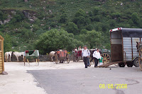 So we parked the car, and negotiated with the jarvies. This proved a little tricky as (not anticipating being unable to use the car) we’d got plenty of money on us, we’d thought, but it was still less than they wanted. But one took pity on us and arranged for a young colleague, “Michael O’Sullivan” (we later learned), to take us up “to the fifth lake” at a discount.
The fifth lake is the topmost one, beyond which you come to the precipice called “the Madman’s Seat,” at the Head of the Gap, and begin the descent into “the Black Valley” on the far side. (It costs extra to complete the last stretch to the top, and a lot more to go down the other side.) The lakes are connected by the Loe River, after which Dunloe Castle is named.

The jaunting cars are widely described as “a rip-off”, and Margaret’s colleague Tom had warned us against them along those lines. Perhaps such critics mean the cars in Killarney itself, for we both felt that Michael and his pony, Mingey (if we caught the name correctly, but it was probably something in Irish; the photo is a different car and pony) worked hard to give us value for money, over more than an hour’s round trip.
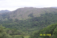
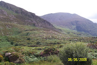 We sat side-by-side in the car, with Michael in front driving Mingey. At first we ascended a leafy lane, with trees either side to conceal the scenery (though of course, the trees were scenery!). Soon the view opened out to show the steep glaciated sides of the mountains, with heaps of till at the feet of the cliffs. It wasn’t cold, though cloudy and breezy, but it was a rather bleak scene, with bare rock, grass, ferns, and heather; the trees had been left behind.
The first lake is called Coosaun Lough (“Lough” being, by the way, an English spelling; in Irish,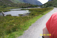 it’s spelt “Loch,” just as in Scottish!). The breeze rustled in the grasses, sent the dandelion heads nodding, and ruffled the waters of the lake, by the side of which there were several fishermen. At
 the head of the lake, the road climbed up to the next little valley, crossing the river by a low- walled bridge, and thereby crossing from the western to the eastern side of the Gap. Looking back, we could see another jaunting car coming up behind us, and a panorama over the Killarney hills in the distance beyond.
 Above Coosaun is a larger lake, known as the Black Lake because
  (it’s alleged) of the shadows cast by the mountains. Ironically, The Irish name for the Black Lake is Loch an Chuasáin, “Lough Coosaun”, which the strangers (as the Irish call the English when they’re being polite) have apparently applied to the wrong lake! (It's Ventry all over again!) Here we saw a heron; although there are supposed to be eagles in the mountains, this was the only bird we saw (or heard, not that it made any sound) throughout our ride up the Gap and back.
At the head of the valley is a cottage which we didn’t photograph because we didn’t know its significance. Reputedly, it’s the cottage of “the Colleen Bawn” (the “Fair Lass”), a fifteen-year old girl “of outstanding beauty” (real name Ellen Hanley) who was murdered in 1819. In reality, the tragedy unfolded in Counties Limerick and Clare, but when it was fictionalised as The Collegians by Gerald Griffin, a reporter of the original trial, the author transferred the central action to the romantic landscape around Killarney (whence the title of Sir Julius Benedict’s later opera, The Lily of Killarney).
Griffin renamed the girl “Eily O’Connor” and had her secretly marry one “Hardress Cregan”, who prepared a hideaway for her until the secret could be made known: “You have heard me speak of Danny Mann's sister, who lives on the side of the Purple Mountain, in the Gap of Dunlough? I have had two neat rooms fitted up for you in her cottage, and you can have books to read, and a little garden to amuse you, and a Kerry pony to ride over the mountains.”
Ultimately, Danny Mann (Cregan’s manservant) murders Eily by throwing her off a boulder into a river, and enterprising locals have identified the very rock near the northern shore of Mucross Lake; a little south of Killarney—reputedly a very nice place to swim! “A stones throw from the beach lies a small but most striking rocky island, perhaps the most famous piece of limestone in Killarney, the Colleen Bawn Rock.”
The road became very narrow above the Black Lake, and it became very clear why cars are frowned upon. Not that everyone bothers to read, or regard, the notice down at Kate Kearney’s. Michael told us that there’d been a serious accident on the road about a year previously, involving a tourist’s car and a pony and trap.
The upward road passes Cushnavally Lake on the right, before leading up to the largest lake, Auger. There are ruins at the north end of the lake which, if we have it correct, are the remains of an old police barracks.
 At the other (upper, south) end of Auger Lake, the road rises very
 steeply between tall, boulder-strewn cliffs, and here Michael had to get down to relieve the weight, and lead Mingey into a trot to provide momentum for the upward trail. The valley walls closed in on either side, with the road clinging to the western flanks of the Purple Mountain, the river below concealed amongst the jumble of huge squarish boulders that had fallen from the sandstone hillsides. Tennyson visited the Gap in his youth, and the famous echo hereabouts (we later read) is said to have inspired his poem, The splendour falls:
The splendour falls on castle walls
And snowy summits old in story:
The long light shakes across the lakes,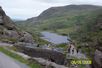
And the wild cataract leaps in glory.
Blow, bugle, blow, set the wild echoes flying,
Blow, bugle; answer, echoes, dying, dying, dying.
 The Gap’s craggy scenic grandeur is internationally famous, and it’s very popular with tourists, as you’d expect of a feature billed as “One of the most beautiful glaciated valleys in western Europe”. The route there takes an “unmarked road to the left” from the N72 (thus Guide Killarney, but when we got to it, the turning was clearly signposted: “Gap of Dunloe”), and down past Dunloe Castle, from which the Gap gets its English name.
The upward-sloping southward road leads towards the mouth of the funnel formed by the mountains to either side, and it’s there, at the bottom of the pass, that you’ll find the car park and Kate Kearney’s Cottage, now (and for a long time since) a café and pub. No-one knows who Kate Kearney was, or even if she really existed, but her reputation is as a moonshiner and a bit of a goer:
Oh have you not heard of Kate Kearney,
Who lives on the banks of Killarney,

At the glance of her eye,
Shun danger and fly,
For fatal's the look of Kate Kearney.
Tho' she looks so bewitchingly simple,
There's mischief in every dimple;
And who dares inhale
Her mouth's spicy gale,
Must die by the breath of Kate Kearney.
The car park turned out to be important. Although cars aren’t banned in the Gap, they’re strongly discouraged “between 10 a.m. and 5 p.m.” (as the sign said) because, as already remarked, it’s “a single-lane dirt track” which (more to the point) is chocker in the season with the slow-moving traffic of pony-drawn jaunting carts.
 So we parked the car, and negotiated with the jarvies. This proved a little tricky as (not anticipating being unable to use the car) we’d got plenty of money on us, we’d thought, but it was still less than they wanted. But one took pity on us and arranged for a young colleague, “Michael O’Sullivan” (we later learned), to take us up “to the fifth lake” at a discount.
The fifth lake is the topmost one, beyond which you come to the precipice called “the Madman’s Seat,” at the Head of the Gap, and begin the descent into “the Black Valley” on the far side. (It costs extra to complete the last stretch to the top, and a lot more to go down the other side.) The lakes are connected by the Loe River, after which Dunloe Castle is named.

The jaunting cars are widely described as “a rip-off”, and Margaret’s colleague Tom had warned us against them along those lines. Perhaps such critics mean the cars in Killarney itself, for we both felt that Michael and his pony, Mingey (if we caught the name correctly, but it was probably something in Irish; the photo is a different car and pony) worked hard to give us value for money, over more than an hour’s round trip.
 We sat side-by-side in the car, with Michael in front driving Mingey. At first we ascended a leafy lane, with trees either side to conceal the scenery (though of course, the trees were scenery!). Soon the view opened out to show the steep glaciated sides of the mountains, with heaps of till at the feet of the cliffs. It wasn’t cold, though cloudy and breezy, but it was a rather bleak scene, with bare rock, grass, ferns, and heather; the trees had been left behind.
The first lake is called Coosaun Lough (“Lough” being, by the way, an English spelling; in Irish,
 it’s spelt “Loch,” just as in Scottish!). The breeze rustled in the grasses, sent the dandelion heads nodding, and ruffled the waters of the lake, by the side of which there were several fishermen. At
 the head of the lake, the road climbed up to the next little valley, crossing the river by a low- walled bridge, and thereby crossing from the western to the eastern side of the Gap. Looking back, we could see another jaunting car coming up behind us, and a panorama over the Killarney hills in the distance beyond.
 Above Coosaun is a larger lake, known as the Black Lake because
  (it’s alleged) of the shadows cast by the mountains. Ironically, The Irish name for the Black Lake is Loch an Chuasáin, “Lough Coosaun”, which the strangers (as the Irish call the English when they’re being polite) have apparently applied to the wrong lake! (It's Ventry all over again!) Here we saw a heron; although there are supposed to be eagles in the mountains, this was the only bird we saw (or heard, not that it made any sound) throughout our ride up the Gap and back.
At the head of the valley is a cottage which we didn’t photograph because we didn’t know its significance. Reputedly, it’s the cottage of “the Colleen Bawn” (the “Fair Lass”), a fifteen-year old girl “of outstanding beauty” (real name Ellen Hanley) who was murdered in 1819. In reality, the tragedy unfolded in Counties Limerick and Clare, but when it was fictionalised as The Collegians by Gerald Griffin, a reporter of the original trial, the author transferred the central action to the romantic landscape around Killarney (whence the title of Sir Julius Benedict’s later opera, The Lily of Killarney).
Griffin renamed the girl “Eily O’Connor” and had her secretly marry one “Hardress Cregan”, who prepared a hideaway for her until the secret could be made known: “You have heard me speak of Danny Mann's sister, who lives on the side of the Purple Mountain, in the Gap of Dunlough? I have had two neat rooms fitted up for you in her cottage, and you can have books to read, and a little garden to amuse you, and a Kerry pony to ride over the mountains.”
Ultimately, Danny Mann (Cregan’s manservant) murders Eily by throwing her off a boulder into a river, and enterprising locals have identified the very rock near the northern shore of Mucross Lake; a little south of Killarney—reputedly a very nice place to swim! “A stones throw from the
 beach lies a small but most striking rocky island, perhaps the most famous piece of limestone in Killarney, the Colleen Bawn Rock.”
The road became very narrow above the Black Lake, and it became very clear why cars are frowned upon. Not that everyone bothers to read, or regard, the notice down at Kate Kearney’s. Michael told us that there’d been a serious accident on the road about a year previously, involving a tourist’s car and a pony and trap.
The upward road passes Cushnavally Lake on the right, before leading up to the largest lake, Auger. There are ruins at the north end of the lake which, if we have it correct, are the remains of an old police barracks.
 At the other (upper, south) end of Auger Lake, the road rises very
 steeply between tall, boulder-strewn cliffs, and here Michael had to get down to relieve the weight, and lead Mingey into a trot to provide momentum for the upward trail. The valley walls closed in on either side, with the road clinging to the western flanks of the Purple Mountain, the river below concealed amongst the jumble of huge squarish boulders that had fallen from the sandstone hillsides. Tennyson visited the Gap in his youth, and the famous echo hereabouts (we later read) is said to have inspired his poem, The splendour falls:
The splendour falls on castle walls
And snowy summits old in story:
The long light shakes across the lakes,

And the wild cataract leaps in glory.
Blow, bugle, blow, set the wild echoes flying,
Blow, bugle; answer, echoes, dying, dying, dying.
The roadway led back across the Loe by a stone bridge, and looking back, we had a wonderful view northwards down the valley towards Beaufort and the fertile lands to the west of Killarney. (And the walkers following up behind us.)

We came at last to the uppermost lake, Black Lough, whence St Patrick is supposed to have banished the very last snake in Ireland. Here we were allowed a glimpse of the next bridge over the Loe, but we hadn’t paid to be taken that last, difficult, kilometre to the Head of the Gap, so Michael turned Mingey and the car around, and we began the journey back down.
Our jaunting-car ride had certainly been worth what we had paid; and it had made a change, being driven instead of driving, and so being able to watch more (and photograph more) than might otherwise have been the case. However, it had consumed virtually all the money we had on us, so we drove back up to the N72 and back into Killarney to find an ATM.
Moneyed up again, we drove south through the town and past the “Lower Lake” and Muckross or “Middle Lake” with the purpose of seeing for ourselves the celebrated Bricín Bridge (see Tuesday 5 Aug 2008: Killarney) which crosses the “Meeting of the Waters” where the water from the “Upper Lake” (Loch Uachtarach, “Lake Superior”) is channelled down through the rocks into Loch Mhucross. This is one of the great beauty spots of Ireland, but we were destined not to see it, since it can only be reached on foot or by jaunty car, and we’d had our jaunt for the day!

Instead, we reversed out course and drove back through Muckross village (Mucros, “Pig Wood”) almost to Killarney. Turning left at Scrahane, we drove through cultivated woodland onto the Ross Peninsula and so to the car parks of Ross Castle.
The peninsula juts out into Lough Leane (Loch Léin), the “Lower Lake”, about a third of the way up its eastern shore. The castle was built in the 15th Century for the O’Donoghue chieftains, on a site overlooking Ross Bay, formed by the northern shore of the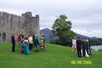 peninsula. The interior can only be visited as part of a tour party, and we were unwilling to join one since they always go so much faster than we want to, being incurable seekers after fine detail. We contented ourselves with viewing the castle’s exterior, and the lovely views out over the bay—and watching the happy bridal parties who are drawn like summer mosquitoes for their photo-shoots. (There were three there already, and another was arriving as we left!)

Ross Castle was one of the last stongholds in Ireland to surrender to Cromwell’s forces, in 1652, and there is a romantic legend of Amy Browne, The Maid of Ross, daughter of the castle warden at the time. The beginning of the story is told at AnswerBank, but the full account doesn’t seem to be on the Internet, so we are providing it for ourselves right here: The Maid of Ross: A Killarney Legend! (Googling “Maid of Ross” returns several hits for an Australian race horse of that name.)
 Had we been able to continue through the Head of The Gap of Dunloe, we would have been taken down to the west end of Loch Uachtarach, the Upper Lake, and boated its length to Newfoundland Bay, where the N71 from Kenmare via Moll’s Gap almost touches its eastern shore (see Monday 4 Aug 2008: Ring of Kerry, and our First Seisiún). Not having done that, we decided
 to do the best we could, and reverse that course, to some extent at least. We drove back down the N71, past the turnoff for the Bricín Bridge, and pulled in at a parking area overlooking Newfoundland Bay. There was a camper-van already there, and we had a pleasant exchange with an elderly couple of vintage hippies … The rocks at the lake’s edge had been worn by the water into fascinating and beautiful rounded shapes …
We continued down the N71 and up to Lady’s View, where we took still more photos of the panorama out over Loch Uachtarach before crossing the road for afternoon tea at the tea shop. We looked for souvenirs (magnets, bookmarks …), but still didn’t find any we wanted to buy. Turning back to Killarney, we tried for Muckross Abbey, but again it seemed we could only get there by jaunting car or on foot, so we went back to Killarney to do some shopping.

 We parked again off College St, our usual location, and went shopping down College and Plunkett
 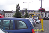 Sts, and then along Main St and High St. We popped in and out of various shops, looking for souvenirs of various sorts, with mixed success. Early on, we found just the right T-shirt for Don, but a search through the racks and boxes found none in his size. Tip: “L” seems to be the most popular size for men’s T-shirts, and the one most likely to run out.
There’s a music shop (Variety Sounds) in College St, and there we found some whistles and wooden spoons for Don. One of the whistles was a Guinness whistle (black with a white fipple for the head …), which Don wanted essentially as a souvenir, but the shop assistant allowed him to try it, and it had a wonderfully sweet tone. The other was an oddity: a wooden whistle, rather than the usual “tin” (light metal alloy), with a plastic fipple. It had a rather slow attack, and a pleasantly breathy, woody tone, and was irresistible.
Along Main St and High St, we found a few relevant fridge magnets (Ireland, Kerry, Killarney, Gap of Dunloe) amongst the thousands of Guinness bottle caps, shamrocks, leprechauns, colleens, and anonymous cottages, and bought several boxes of Irish sweets for work colleagues. But despite all the shops we went into, we still couldn’t find “the T-shirt” in Don’s size, or any other that either of us liked as much.
Since it was to be our last night in Killarney, and our last seisíun there, we decided on dinner at Farrell’s “Crock of Gold”; but it was very full, and they were only accepting foursomes (i.e., tablefuls). After waiting at the bar a while, we caught the maître d’ and said we’d be happy to share. He was back in a short while, to lead us to a table where a young Canadian couple were sitting. We chatted as we waited for food, and for the seisíun: their names were Scott and Diane; they were taking the opportunity to visit Western Europe in conjunction with a conference Diane was attending in England.

The seisíun was good, but it was a different pair of performers. Although they sang a couple of chorus songs we were able to join in with, they mostly played instrumentals, jigs and reels that we didn’t know and Don couldn’t play along to. Not quite what we’d wanted for our last night in the Irish Republic; but it had been a good session nonetheless.
And so back to Aghadoe Cottage, for the last time …

We came at last to the uppermost lake, Black Lough, whence St Patrick is supposed to have banished the very last snake in Ireland. Here we were allowed a glimpse of the next bridge over the Loe, but we hadn’t paid to be taken that last, difficult, kilometre to the Head of the Gap, so Michael turned Mingey and the car around, and we began the journey back down.
Our jaunting-car ride had certainly been worth what we had paid; and it had made a change, being driven instead of driving, and so being able to watch more (and photograph more) than might otherwise have been the case. However, it had consumed virtually all the money we had on us, so we drove back up to the N72 and back into Killarney to find an ATM.
Moneyed up again, we drove south through the town and past the “Lower Lake” and Muckross or “Middle Lake” with the purpose of seeing for ourselves the celebrated Bricín Bridge (see Tuesday 5 Aug 2008: Killarney) which crosses the “Meeting of the Waters” where the water from the “Upper Lake” (Loch Uachtarach, “Lake Superior”) is channelled down through the rocks into Loch Mhucross. This is one of the great beauty spots of Ireland, but we were destined not to see it, since it can only be reached on foot or by jaunty car, and we’d had our jaunt for the day!

Instead, we reversed out course and drove back through Muckross village (Mucros, “Pig Wood”) almost to Killarney. Turning left at Scrahane, we drove through cultivated woodland onto the Ross Peninsula and so to the car parks of Ross Castle.
The peninsula juts out into Lough Leane (Loch Léin), the “Lower Lake”, about a third of the way up its eastern shore. The castle was built in the 15th Century for the O’Donoghue chieftains, on a site overlooking Ross Bay, formed by the northern shore of the
 peninsula. The interior can only be visited as part of a tour party, and we were unwilling to join one since they always go so much faster than we want to, being incurable seekers after fine detail. We contented ourselves with viewing the castle’s exterior, and the lovely views out over the bay—and watching the happy bridal parties who are drawn like summer mosquitoes for their photo-shoots. (There were three there already, and another was arriving as we left!)
Ross Castle was one of the last stongholds in Ireland to surrender to Cromwell’s forces, in 1652, and there is a romantic legend of Amy Browne, The Maid of Ross, daughter of the castle warden at the time. The beginning of the story is told at AnswerBank, but the full account doesn’t seem to be on the Internet, so we are providing it for ourselves right here: The Maid of Ross: A Killarney Legend! (Googling “Maid of Ross” returns several hits for an Australian race horse of that name.)
 Had we been able to continue through the Head of The Gap of Dunloe, we would have been taken down to the west end of Loch Uachtarach, the Upper Lake, and boated its length to Newfoundland Bay, where the N71 from Kenmare via Moll’s Gap almost touches its eastern shore (see Monday 4 Aug 2008: Ring of Kerry, and our First Seisiún). Not having done that, we decided
 to do the best we could, and reverse that course, to some extent at least. We drove back down the N71, past the turnoff for the Bricín Bridge, and pulled in at a parking area overlooking Newfoundland Bay. There was a camper-van already there, and we had a pleasant exchange with an elderly couple of vintage hippies … The rocks at the lake’s edge had been worn by the water into fascinating and beautiful rounded shapes …
We continued down the N71 and up to Lady’s View, where we took still more photos of the panorama out over Loch Uachtarach before crossing the road for afternoon tea at the tea shop. We looked for souvenirs (magnets, bookmarks …), but still didn’t find any we wanted to buy. Turning back to Killarney, we tried for Muckross Abbey, but again it seemed we could only get there by jaunting car or on foot, so we went back to Killarney to do some shopping.


 We parked again off College St, our usual location, and went shopping down College and Plunkett
  Sts, and then along Main St and High St. We popped in and out of various shops, looking for souvenirs of various sorts, with mixed success. Early on, we found just the right T-shirt for Don, but a search through the racks and boxes found none in his size. Tip: “L” seems to be the most popular size for men’s T-shirts, and the one most likely to run out.
There’s a music shop (Variety Sounds) in College St, and there we
 found some whistles and wooden spoons for Don. One of the whistles was a Guinness whistle (black with a white fipple for the head …), which Don wanted essentially as a souvenir, but the shop assistant allowed him to try it, and it had a wonderfully sweet tone. The other was an oddity: a wooden whistle, rather than the usual “tin” (light metal alloy), with a plastic fipple. It had a rather slow attack, and a pleasantly breathy, woody tone, and was irresistible.
Along Main St and High St, we found a few relevant fridge magnets (Ireland, Kerry, Killarney, Gap of Dunloe) amongst the thousands of Guinness bottle caps, shamrocks, leprechauns, colleens, and anonymous cottages, and bought several boxes of Irish sweets for work colleagues. But despite all the shops we went into, we still couldn’t find “the T-shirt” in Don’s size, or any other that either of us liked as much.
Since it was to be our last night in Killarney, and our last seisíun there, we decided on dinner at Farrell’s “Crock of Gold”; but it was very full, and they were only accepting foursomes (i.e., tablefuls). After waiting at the bar a while, we caught the maître d’ and said we’d be happy to share. He was back in a short while, to lead us to a table where a young Canadian couple were sitting. We chatted as we waited for food, and for the seisíun: their names were Scott and Diane; they were taking the opportunity to visit Western Europe in conjunction with a conference Diane was attending in England.

The seisíun was good, but it was a different pair of performers. Although they sang a couple of chorus songs we were able to join in with, they mostly played instrumentals, jigs and reels that we didn’t know and Don couldn’t play along to. Not quite what we’d wanted for our last night in the Irish Republic; but it had been a good session nonetheless.
And so back to Aghadoe Cottage, for the last time …


